
Accomplished Projects
The impact of Digital Technology has been felt in almost all sectors that are particularly important in human development. E-Governance offer new possibilities for improved essential services system, new ways of citizens’ empowerment and active participation in their societies at both social and political levels. Also, the possibilities of enhanced monitoring, accountability and learning has filled a large gap by encouraging systems that can be managed distantly.
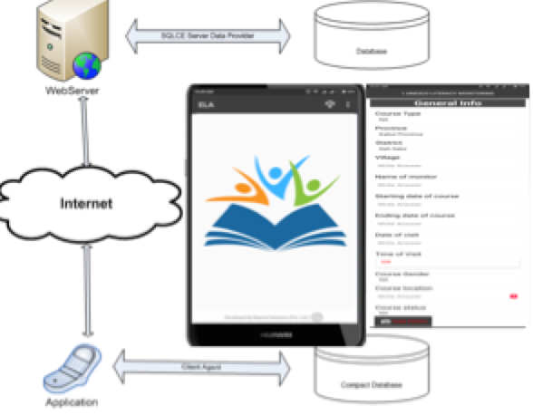
Customization of Mobile Application and Third Party Monitoring of SALA Project
Country: Kabul, Bamyan, Heart, Helmand, Nangrahar Provinces, Afghanistan
Name of Client: Fast Track
Start Date: January 2019
End Date: May 2019
In 2018 Fast Track Information Technology Services and Beyondsolutions Private Limited jointly implemented the project titled ‘Development of Mobile Application, M&E of ELA Literacy Project’ (Ref# KAB/17/EDU/RFP/02ted) in partnership with UNESCO Afghanistan and MoE. The project resulted in the development of ELA Mobile Application based on existing supervision tools used by ELA staff and was piloted across 600 ELA courses in 5 provinces of Afghanistan. The data gathered through the pilot survey provided a rich analysis and an accurate snapshot of the functioning of the courses. As step forward, UNESCO SALA project announced RFP to enhance the ELA application and perform third party monitoring of Literacy courses that include 231 BGL and 33 SBL courses in 21 districts of 5 provinces. The project will not only help the client to monitor the ongoing literacy courses but at the same time will be an important step (for the Literacy Department) towards the use of Information and Communication Technology-ICT for the monitoring and evaluation of its projects.
The project consists of :
a) gathering data from 231 BGL and 33 SBL courses in 21 districts of 5 provinces.
b) Customization of ELA Mobile M&E tool.
c) integration of the of the system with NFEMIS d) submit two data analysis reports.
Enhancement of Literacy in Afghanistan (ELA)
Country: Afghanistan
Name of Client: Fast Track/UNESCO
Start Date: January 2018
End Date: April 2018
The Program for Enhancement of Literacy in Afghanistan (ELA) is a national program of Ministry of Education (MoE) that aims to improve the level of basic literacy, numeracy and vocational skills of the adult population (above 15 years) and is implemented in all 34 provinces of the country. UNESCO works in close collaboration with MoE on the ELA programme since 2008.
With the aim to strengthen the overall monitoring system of Literacy Department (LD) as well as the ELA, UNESCO awarded a project to Beyondsolutions and Fastrack for developing a mobile application that will help improving the quality and effectiveness of the ELA courses. The use of this technology solution will strengthen the transparency and accountability in project implementation and will establish a distant monitoring system in a context where access related challenges hinder the possibility of frequent visits to some of the remote locations.

PROMOTE Survey
Country: Afghanistan
Name of Client: RSI Consulting
Start Date: April 2015
End Date: September 2015
Promote is a five-year program targeting the education, promotion, and training of a new generation of Afghan women, aged 18-30. It is the largest women’s empowerment program in the USAID’s history, aimed at advancing opportunities for Afghan women who can become political, private sector, and civil society leaders.
Building upon existing and previous programs for women and girls.
- Deployed questionnaire in our Pocket Survey tool in three languages i.e. English, Dari, and Pashto.
- Provided secure hosting servers.
- Trained more than 100 field staff on how to fill questionnaires, sync data, send alerts and etc. through Pocket Survey application from smart phones.
- System maintenance during the field work.
- Provided status reports on daily basis.
PRADP-N Survey
Country: Afghanistan
Name of Client: RSI Consulting
Start Date: September 2014
End Date: March 2015
RADP-N is five year project, funded by USAID The RADP-N aims to advance food and economic security for rural Afghans in the Northern provinces of Balkh, Jowzjan, Samangan, Baghlan, Kunduz and Badakhshan.
- Deployed questionnaire in our Pocket Survey tool in three languages i.e. English, Dari, and Pashto.
- Provided secure hosting servers.
- Trained more than 75 field staff on how to fill questionnaires, sync data, send alerts and etc. through Pocket Survey application from smart phones.
- System maintenance during the field work.
- Provided the collected data in the MS Excell to the client for further analysis.
OTI Survey
Country: Afghanistan
Name of Client: RSI Consulting
Start Date: March 2014
End Date: August 2014
Develop Android based Native Mobile application for Monitoring and Evaluation of USAID Projects for Rehman Safi International (RSI) consultancy company in Afghanistan. The application consists of multiple M&E tools for assessment of OTI Projects. The application support both online and offline data collection and multimedia recording.
- Deployed questionnaire in our Pocket Survey tool in three languages i.e. English, Dari, and Pashto.
- Provided secure hosting servers.
- Trained more than 52 field staff on how to fill questionnaires, sync data, send alerts and etc. through Pocket Survey application from smart phones.
- System maintenance during the field work.
- Provided the collected data in the MS Excell to the client for further analysis.

DABS
Country: AfghanistanName of Client: PA Government Services Inc.an
Start Date: 18 July 2010
End Date: December 2010
Provincial Infrastructure Management Support System (PIMSS) has got bellow different modules integrated with each otherBeyond Solutions team worked closely with Kabul Electricity Service Improvement Program (KESIP) for the implementation of the GIS regularization program. Purpose of the project was to work with Da Afghanistan Breshna Sherkat (DABS) and use GIS techniques and maps to identify customer premises, assign billing sequence and review meter reading routes. The project consisted of the following main modules.
- Digitization of Kabul District Maps for premise identification and boundaries.
- Geo-Coding of premise for identification and linkage to GIS system for mapping the information.
- Mobile Survey Application (MSA) to gather information and coordinates of premise, meter, transformer and pole. This module also provided mechanisms for data verification and correction.
- Development of Geo Database to provide spatial reports about premise, customer, meter and transformers.
The MSA enabled survey teams to collect accurate and reliable information about customers, meters and premises. The tool also captures the GPS coordinates of meter, transformer and premise to help in better mapping and linking of customer with meter and the premise. Considering the procedure of survey and skills of the surveyors, it was essential to collect the data through a user-friendly interface in order to increase the usability and effectiveness of the system, MSA provides a visualized presentation layer for both input and output.

PIMSS
Country: Afghanistan
Name of Client: Government of Afghanistan
Start Date: 22 Feb 2009
End Date: 15 April 2010
Provincial Infrastructure Management Support System (PIMSS) has got bellow different modules integrated with each other:
- PIMSS Web Application.
- PIMSS Mobile Application.
- PIMSS & Primavera Integration.
Data collection and verification is an important aspect of PIMSS. In order to ensure the accuracy of data that has been aggregated and entered from different users and provincial departments, mobile application was built and used by the surveyors for this purpose. The PIMSS mobile Module has different interfaces for the surveyors to access the assigned tasks through a mobile device from the server; the system enables the surveyors to locate projects and assigned assets on map where he/she was assigned to conduct the data verification. The mobile interfaces automatically report the exact coordinates (Latitude and Longitude), upload geo-tagged images of an asset/ project and report the necessary complements of an asset and project through the user interface.